 Bishop Hill
 Another climate station
 Jun 1, 2007
  Climate: Surface
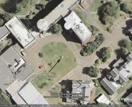
 Following on from the previous post, I thought it might be interesting to take a look at a UK climate station on Google Earth. The idea was really just to see if I could find the "Stephenson Screen" - the small box of tricks used for recording climate data rather than to do any surveying as such. . My nearest stations are Edinburgh Airport and the Royal Observatory. Taking the view that the Observatory would be smaller I zoomed in on Blackford Hill, and was pretty astonished to find what appeared to be the climate station straight away.

As you can see, the station (marked) is surrounded by a circle of grass. By the miracles of Google Earth I was able to measure this as having a minimum radius of 9m which is the bare minimum permitted by the guidelines. The surrounding roads are a no-no though, and the buildings around the perimeter are too close to the station which should be at least a distance of four times the height of the buildings away. Since we can measure the distance to the nearest building as being 18m this implies a maximum height of the building of 4.5m. This seems implausible.
All in all, it looks as though there may be problems with data quality in the UK too - if it can't be got right at a major scientific institution it's unlikely that the stations in agricultural colleges and so on are going to be much better. It's a pity that the Google's hi-res images of the UK cover such a small fraction of the country.


Reader Comments (2)
ftp://ftp.ncdc.noaa.gov/pub/data/ghcn/v2/v2.temperature.inv