


 Bishop Hill
 Sea level and the diving horses
Climate: WG2 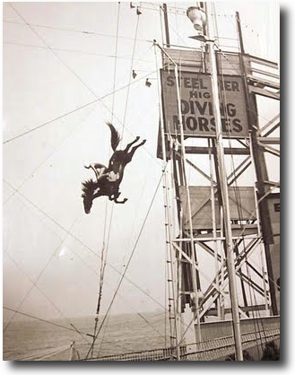 There's a fascinating article in the Washington Times (H/T Josh) by Willie Soon and Nils-Axel Morner. They tell the story of one Cyril Galvin, who found a problem with his local tide guage figures.
In examining sea-level changes for 100 years or more from stations on the Eastern Seaboard, Mr. Galvin could not find any acceleration in sea-level rise. University of Florida professor Robert Dean and Army Corps of Engineers analyst James Houston have independently reached this same conclusion.
While examining tide gauge records from Atlantic City's Steel Pier, Mr. Galvin discovered a remarkable effect apparently caused by spectators who came to watch horse-diving between 1929 and 1978. From old photographs, it was estimated that there must have been about 4,000 spectators who would come to watch. Given that this crowd probably weighed about 150 tons, the pier was subject to significant loading and unloading cycles. The initial 1912-1928 data showed the sea level rising at a rate of 0.12 inches per year. The rate tripled around 1929 when the horses began diving. When the shows were suspended from 1945 to 1953, sea level fell at a rate of 0.06 inches per year. When the diving resumed, the sea level rose again at a rate of 0.16 inches per year.
Reader Comments (60)
Diving horses.... now that is an insane sport! Great photo and an interesting read :-)
Sea Horses cause sea level rise ....
Tide gauges are notoriously unreliable. They jump when there is an earthquake. They used to read manually or not when it's Christmas or the readers are on strike -- the Thatcher years are largely missing in the UK.
A clever statistician would be able to detect a common trend from individual gauges ...
When CO2 levels go up then horses start diving and the sea level rises. When there is a (temporary) pause in the rise of CO2 the horses stop diving. Quite simple really.
Best laugh of the week, there.
Pity in a way that Andrew will delete it! <;-)
Ooops. He already did. Sorry!
Cyril Galvin and Robert Dean are both esteemed engineers and researchers in the fields of ocean and coastal engineering. I had the good fortune to work with Dr. Dean at one point in my career.
Sea levels could be described as stable......
An instructive example. Measurement errors of one kind or another are usually well worth checking for whenever a surprising result is found!
Data from here (press download link)
Plotted here
Shows sea levels reducing from both ENVISAT & JASON
Odd that. Perhaps the sea levels are hiding in the deep ocean with the missing heat :-/
There must have been a lot of horse wastage to cause that much displacement!:)
ssat
Do you have standard deviations or 95% confidence limits for that sea level data?
I wonder if they ever got a horse to repeat the performance. There is a maker at Jamestown Rhode Island that reports that they have raised the dock 8 inches due to same increase in mean low tide height since 1938.
I think this was done without benefit of an agenda.
One of the longest tide gauge records is New York. It extends from 1856 to the present, with a gap from 1879 to 1892. The rate of sea level rise measured over the whole period is 2.839+/- 0.045mm/a. Over the period 1856 to 1949 it is 2.549+/-0,096mm/a. Over the period 1950-2012 it is 3.066+/-0.166mm/a. As accelerations go, I think snails are in Formula 1.
http://tamino.wordpress.com/2012/12/18/horseshit-power/
:)
Am I missing something here or are both Tamino and Zed so incensed at the mention of the names Morner and Soon (presumably the combination of the two in the same place has a geometric rather than an arithmetic effect on their rage) that they are totally incapable of understandding what this is?
I don't see anything in this which is an attempt "to pass off ... claptrap as though it were actual science". If anything they are pointing up the dangers of not taking into account all the relevant data before coming to a conclusion.
Personally I read it solely as an interesting piece of American social history, nothing else.
Have you got a reference on that Jamestown RI quote?
Posted this in unthreaded too but as this is a 100 year topic too its related.
Capt Scott campsite found 100 years later, 2 pics 100 years apart and is there any change in snow cover.
http://www.dailymail.co.uk/news/article-2250014/British-professor-discovers-lost-campsite-Captain-Scotts-doomed-Antarctic-expedition-100-years-used.html
No !!!!!!!!!!!!!!!!!
So no dramatic sea rise, methane levels increasing at previous levels etc etc
Not a lot going on in 100 years.
MJ, why not read Tamino's article. Here's a quote to save you the bother:
Tamini brain explosion
The sea level plots for Atlantic City, Key West and Pensacola look ... different.
One should never believe one who sputters in rage.
I preferred the story as presented by His Grace, it was funny plus we got piccies.
ZedDeadBed (or however it's spelt) briefly had a dismissive and derogatory (or however it's spelt) comment about 'dowsing' - well, ZDB, you're very welcome to come down to central Hampshire and meet my old tractor driver, who we used to rely on to find leaking water pipes as they crossed the farm. Armed with his trusty two right angles of, er, coat hangar, he was faultless - once we'd worked out that the pipe was always under his feet; marking the gound directly under the wires as he walked left and right resulted in a zig zag pattern. Then, the pipes, which were put in the farm by Italian POW's in 45/46 finally got too porous (like my Alfasud), and the landlord replaced the whole lot with blue PVC. So we haven't had to call on him to track a new pipe....yet.
Sorry, I digress.
We have around 5-15 metres of tidal range twice every single day. Somebody please, please tell me how you detect a few a few millimetres of difference over years and years.
my question exactly, Vernon...a few mms is not measurable on the tidal change scale we have
Charlie Flindt,
The two bent wire coat hanger method served me very well for 30 years in the construction business. If there was any kind of pipe, duct or cable running across a site, I could find it. People can laugh as much as they like, but it works. And who showed me how to do it? That’s right, a chartered engineer! Who lived in Four Marks in Hants by the way.
Tamino shows Laurie the hand! lmao
Re: the Jamestown RI increase in mean low tide. The 8 inch increase since the '30s was recorded on a bronze plaque on the north side of the island. I read it. If you're near there I can tell you where to look for it.
Thankyou, BitBucket.
Add the quote you found to the one Mark S gave us and Tamino ends up looker an even bigger humourless whinger.
And your point was what, precisely?
mmm...did Tamino talk nthat way about those temperature reconstructions from tree-rings by that rookie scientist Mike Mann....those ones that did not realise that a narrow ring could mean a low temperature or a temperature so high that the tree stopped growing? maybe we should respect Tamino...he knows something about forcing his ideas onto data.
I was taught how to use the two bent coat hangers by a chap from the water company when we were searching for the water main that ran through our garden. They worked a treat.
Well, I don't know if I buy the argument that there's a statistically significant difference in the tide gauge data that I can tie to horse diving, but if you look at AC and the other cities Tamino mentioned, I see as much "acceleration" as my old Ford Pinto used to demonstrate.
http://tidesandcurrents.noaa.gov/sltrends/sltrends.html
BTW, I once witnessed a diving mule show in the early 80s at a local fair. The mule dove repeatedly, and by all appearances happily into an above ground pool. Even had a monkey that rode its back during some of the dives.
Can someone please help me with this? From Ordnance survey...
http://www.ordnancesurvey.co.uk/oswebsite/gps/docs/A_Guide_to_Coordinate_Systems_in_Great_Britain.pdf
"Many other small effects can be observed – the sinking of Britain when the tide comes in over the continental shelf (a few centimetres), the sinking of inland areas under a weather system ‘high’ (about 5 millimetres), and the rising of the land in response to the melting of the last Ice Age (about 2 millimetres per year in
Scotland, up to 1 centimetre per year in Scandinavia)."
What I don't understand is how the ground can be so elastic as to respond to a change of air pressure in a matter of hours, and yet so inelastic as to take 10,000 years to respond to the loss of ice.
Dear Mr Cometh, you're working to thousandths of a millimetre! Is that appropriate to the data?
Tide gauges are a minefield.... in the short term they are fit for purpose if correctly surveyed in.
A pre GPS tide gauge data set is to my mind pretty much worthless as a measure of millimetres of historical sea level rise unless fully documented and regular mm level geodetic control and calibration was undertaken and this simply is *not* the case for the vast majority of tide gauges.
I suspect that every practicing hydrographic surveyor has a stock of tide gauge horror stories :-)
When you start looking at really tiny measurements it gets worse. I remember when RS Components started selling high precision electronic scales and the scales were calibrated in once place and sent all over the place where umm... gravity was different :-).
However as Shub has noted - willful instant misrepresentation is a common tactic out there in AGW activism land ...
A bit more on the 8 inch increase in mean low tide level over 60 years in Jamestown, Rhode island. I only mentioned it because it was memorialized on a bronze plaque at the location of the change. No words about generality - just what happened at that dock. could have been subsidence.
And all that time, water came half-way up a horse.
Thank you ssat Dec 18, 2012 at 5:31 PM
It is comforting that the tiny upward bumps each year (if nt noise) correspond to the southern summers, with most water mass south of the equator.
BTW, in the leaked IPCC AR5 draft chapter 3 page 4,
"22 It is virtually certain that globally mean sea level (GMSL) has risen at a mean rate between 1.4 to 2.0
mm yr–1 over the 20th Century and between 2.7 and 3.7 mm yr–1 since 1993 (99% confidence limits).
This assessment is based on high agreement between multiple studies using different methods and independent observing systems (tide gauges and altimetry) since 1993. It is likely that GMSL rose between 1930 and 1950 at a rate comparable to that observed since 1993, possibly due to a multidecadal climate oscillation, as individual tide gauges around the world and reconstructions of GMSL show increased rates of sea level rise during this period. High agreement between studies with and without corrections for land motion suggests that it is very unlikely that estimates of the global average rate of sea level change are affected by land motion. [3.7.2, 3.7.3, Table 3.1, Figures 3.12, 3.13]”
There's room for several articles dissecting that comment. For example, there are some substantial 'adjustments' with equipment changes. Are they right?
Sleepalot
Your Ordinance Survey comment is poorly worded.
There is a slow sinking of the Southeastern British coastline as the North rebounds after sinking deeper into the mantle under the weight of ice sheets during the last glacial period, a process known as isostatic uplift.
The response to high pressure is a slight drop in sea level under the increased mass of air, not a change in the level of the land surface. The opposite effect, a raised sea level under a low pressure system , is one factor producing a storm surge. This is one reason why the North Sea floods were so severe in 1953 and why Sandy was so destructive in 2012.
The concern regarding increasing sea levels tends to be misinterpreted in terms of normal tides, when the real concern is that storm surges which were previously benign become high enough to overtop sea defences. Trenberth recently speculated that increased sea level since the last Sandy type event 50 years ago made the difference between the New York subway staying dry or flooding.
tomo
"willful instant misrepresentation is a common tactic out there in AGW activism land ..."
And in scepticland.
@ Entropic Man
So when the OS say "the sinking of inland areas under a weather system ‘high’ (about 5 millimetres)" you think they're talking about storm surges affecting sea level?
What does "inland areas" mean to you? To me, it seems to suggest _land_ that is away from the coast.
The president of the Humane Society of the United States stated: "This is a merciful end to a colossally stupid idea."
Not global warming, but horse diving. This is a real video.
http://www.youtube.com/watch?v=ZEkPQ6xDWMc
Warning - horse slightly hurt in this.
Horse tramples car
http://www.youtube.com/watch?feature=fvwp&v=tI9g9ks6aUI&NR=1
The author claimed it happened in Norway. The best comment was "are there deserts in Norway ?". They were Americans. No damage done.
Charlie Flindt (5:03 PM): "Sea levels could be described as stable..."
Such classic wit must not be allowed to go unremarked.
"From old photographs, it was estimated that there must have been about 4,000 spectators who would come to watch."
-So that's how they used to do pier-review back then in the USA? The UK fashion looked more like this: TinyURL.com/old-style-pier-review
Old stle pier-review?
http://tinypic.com/r/15wi3xv/6
While not normally a fan of Tamino, lets give credit where credit is due. Various plots provided do suggest a regional slow down of sea-level rise for a period starting around 1940, despite the details of the plots showing variations. This suggests some other effect (regional / global) rather than crowds causing subsidence at a single location. What is also interesting is that the same plots, in some cases, suggest a slower rate of sea-level rise from about the mid 1990's.
I know, this comment is not about tidal gauges but it IS about the image of a diving horse/rider: There is a movie about a diving horse (and "diving girl" rider), based upon a true story that culminated at Atlantic City's Steel Pier:
Wild Hearts Can’t Be Broken is a 1991 film about Sonora Webster Carver, a rider of diving horses
It's Disney so quite romanticized, but does give a sense of the phenomenon.
Re ground movement due to tides,
A friend of mine was a trouble shooting engineer, working at Berkeley Nuclear Labs,, at Berkeley nuclear power station on the bank of the river Severn.
One of the projects he did was to determine why one of the huge concrete turbine beds in the turbine hall had cracked.
They put some instrumentation on, and found the concrete raft rose and fell by up to 25mm on every high spring tide, due to the hydrostatic pressure of the high tide !
Cheers
P
Re-reading my previous comment, just seen that I dropped a decimal point, rise should have been 2.5mm NOT 25mm
Duh!!
P
Entropic man @ 1:53 AM
quite.
The wholesale and irrational rush to grab the publicity initiative and blame anything that comes to hand as attributable to Global Warming and rapidly counter any "heresy" is deeply wearisome. My perception is that the warmists are particularly egregious in this with the folk at Skeptical Science leading the pack. The regularly sneery tone of Tamino grates. It seems to me that advocacy comes first and honesty and diligence are also-rans.
I have been involved in correcting geodetic height survey data sets after GPS observations were made and seen loads of deeply compromised tide gauge data. Non GPS referenced date for global sea level rise? - tree rings look simple in comparison.
@Entropic man
"Trenberth (recently) speculated"- that is about all he can do.
The man is a disgrace to the word "scientist".