


Saturday
Nov272010
by  Bishop Hill
Bishop Hill The Arctic gap
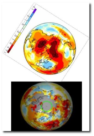
Climate: Surface Andy Russell has posted an interesting graph in an attempt to provide support for the notion that things are still warming up, despite the cold we are experiencing in the UK at the moment.
The GISS derived figure shows a view of Arctic temperature anomalies, with the pole apparently experiencing temperatures 4-7° (not sure if this is F or C) above normal.
The problem with this is that there is almost no data to support this, as Stephen Goddard has previously shown. (GISS fill in with model-derived numbers, upon which nobody should surely place any reliance.) I've constructed a composite of Andy's GISS chart and Goddard's figure showing which gridcells have real data to support them.
Reader Comments (74)
Question -- an alarmist made the claim in an argument that the GISS methodology (in making adjustments and extrapolations like this) is well-known, peer-reviewed, and beyond challenge. That wasn't my understanding, but I don't know the details. Would appreciate someone who knows providing a short summary of the situation.
Stan
Unfortunately, unravelling the GISTEMP methodology doesn't lend itself to a short summary.
The crux of the problem is that GISS doesn't use sea surface temperatures (SSTs) properly when calculating its gridded temperature data set for Northern high latitudes.
First, areas of ocean with seasonal sea ice cover are masked (overlaid) with extrapolated land surface temperatures (LSTs).
Then the extrapolation is used to 'fill in' the polar cap.
The result is a very 'warm' Arctic based on very limited actual data that has been used in a way that guarantees exactly such a result.
The trend in temperature increase is much higher in LSTs than SSTs, so the is artificially elevated.
The following link goes into much more detail and may be of value:
http://bobtisdale.blogspot.com/2010/05/giss-deletes-arctic-and-southern-ocean.html
Surely this filling-in with interpolation of adjusted data is literally data fabrication!?
Sorry - dropout typo:
No, no, Simon, that's a terrible thing to say. James Hansen would be most upset.
WUWT ran this back in March of this year re questions of the GISS data set:-
"NASA Data Worse Than Climate-Gate Data, GISS Admits"
The following taken from an FOI'd email back 2007.
"My recommendation to you is to continue using NCDC's data for the US
means and Phil Jones' data for the global means."
http://wattsupwiththat.com/2010/03/30/nasa-data-worse-than-climate-gate-data-giss-admits/
Any temperatures derived from extrapolation or a model are invalid, fabricated nonsense. End of story.
If I were to take the temperature at either end of my living room (which is nice and toasty due to the wood burner going full blast) and extapolate into my garden, I would be out there working in my shorts and t-shirt.
Anyone interested in a quick overview of Arctic temperature change over time can look at Prof. Ole Humlum's excellent site Climate4you:
http://www.climate4you.com/
Unfortunately, the way the site is organised doesn't let me link directly to the relevant section. So, just click Polar Temperature in the index at the left, and then scroll down.
Look carefully at the first figure. Note the WMO normal (the baseline climatology) from which the anomalies are calculated (hint - it's in a cold period so warmer temperatures will give large anomalies from the baseline).
Now look at the 1920 - 1935 warming episode, and compare the height of the peak (1934-5) with current Arctic temperature. Interesting, isn't it?
I should add that pre-1920, data are sparse, and less reliable, so that apparently huge step change is probably an artifact rather than a measurement.
This explains Trenberths problem over the missing heat. It is only found in the places where they have no thermometers, Arctic, Bolivia, Sahara etc
These are also areas with no trees, but this may be a coincidence
OT Bish, but James Delingpole has praise (of a kind) for you. http://blogs.telegraph.co.uk/news/jamesdelingpole/100065683/why-i-now-deeply-regret-my-last-post/
I do find it amusing that you insist that GISS is secretly using 'model' data in their analysis - even though the code is online and independently replicated and no input of 'model' data can be discerned. This demonization of model output is also amusing since you think so highly of the DMI Arctic temperature analysis (which is from the ECMWF weather forecasting *model*). And of course, your insistence that the GISS interpolation (note that the world doesn't end at 90N) can't possibly be an reasonable estimate without even a cursory search for any other source for that data. Umm... oh how about this?
http://nsidc.org/images/arcticseaicenews/20101102_Figure4.png
But don't let reality get in the way of trying to find some reason to think that all those climate scientists must either be knaves or fools.
Fred
I must be getting old and careless. I completely missed the reference to DMI in the headpost.
Or perhaps that was a straw man...?
Not all derived Artic temperatures show warming.
http://ocean.dmi.dk/arctic/meant80n.uk.php
GISS is an outlier comapred to other datasets.
Fred care to show us were anyone claimed what they do is a 'secret'
Also, doesn't NOAA actually use GISTEMP as its source data?
Oh, and Fred:
The correct term for projecting data into a void is 'extrapolate'. GISTEMP's Arctic estimate is an extrapolation based on a poor choice of data (LSTs extrapolated over SSTs).
Infilling blanks between two data points is interpolation.
The former is a dangerous business in science, as you really should know.
So if there is a rise in the anomoly of 4*C from minus twenty, uh it's still pretty f'n cold!
Apologies - poorly phrased above:
Should have added 'for current Arctic temperature estimates'
Fred
"those climate scientists must either be knaves or fools" as a professional real scientist of almost 4 decades I could put it any better myself
Wow. So many fallacies so little time!
BBD asks who used the DMI estimate, and the next poster does!
BBD then just imagines that NOAA must be using the GISTEMP product, because how could they possibly agree otherwise?
KnR thinks that it isn't a secret that GISTEMP uses model data - yet no-one has actually shown a piece of the (freely available) code where this happens. So you have to either accept that GISTEMP doesn't actually use model data (which would be true), or you have to be claiming that the 'model' adjustment must be secret (which would be wrong, but perhaps comforting). Don't see how there any other options.
Oh and if you have data on one side of a basin, and data on the other side of a basin and you want to estimate the data in-between, that would be an interpolation.
DeNihilist moves straight to the 'oh well, even if it's warming, what difference does that make'
There are many things in climate change that are unpredictable; the comments here are clearly not.
Your comment is awaiting moderation. (at "Our Clouded Hills")
Now there's a surprise.
Thank you to all who took time to respond. I don't think I phrased my question well. It isn't a question about the science. It's a question about the argument. I understand that GISS is basically saying -- "the temperatures we can measure are near normal, therefore we conclude that the temperatures we can't measure are hot as hell." One doesn't need to be a scientist to raise an eyebrow of curiosity about that kind of logic.
My question relates to the status of the argument over GISS. Who has put a stamp of approval on this slop? Who has critiqued it? What are the responses to the critics of the critiques, etc.? Essentially, how much careful study and review has been directed at this methodology and, if any, where does it all stand?
Fred
I am not prescient, so your remark is fatuous. This provides ample insight into your intent.
I asked you a question which you did not answer. Instead you make another snide comment. I will assume that either: I am right or: you don't know the answer.
In either case, you resort to pointless snark, which confirms your intent.
The headpost could be better expressed.
As could you, Fred.
'Modelled' was used where 'extrapolated' would have been correct.
You, I note, avoid answering my point regarding the correct usage of 'extrapolated' vs 'interpolated' above.
It's all noise and no substance so far.
Might I suggest a move to the substantive, or a quick end to what is looking like a thoroughly pointless exchange?
If you think that is interpolation, you are beyond hope.
Does Fred seem to think that we can get the temperature on the equator by interpolating between temperatures at the N and S poles? Or am I missing something?
Let me explain:
Here we have some coastal SST data for the West coast of Ireland (x) and here some for the Eastern seaboard of the US (y).
Please now explain how you support your definition of 'interpolation' in the context of deriving an average value for SSTs across the N Atlantic basin?
This is why I prefer to call a spade 'extrapolation' in this context.
Philip - sorry, that was in response to Fred, not you.
But you clearly understand anyway!
Fred "There are many things in climate change that are unpredictable; the comments here are clearly not."
I agree with the first part of the sentence. I am sure most would
Can you confirm that you predicted this?
Fred's understanding of interpolation may well be coincident with that of GISS.
Projection becomes simulation becomes reality...
I have a question though...
Are they any instances of such large surface areas being projected, and the projected anomaly is neutral or negative?
It just seems that wherever we have instances of locations not being tied to actual data (assuming that data "valid", and that is a big assumption) we get these large positive anomalies.
So are there are such projected areas? Serious question.
BBD, indeed I do.
See GISS page here:
http://data.giss.nasa.gov/gistemp/abs_temp.html
Excerpt:
Q. If SATs cannot be measured, how are SAT maps created ?
A. This can only be done with the help of computer models, the same models that are used to create the daily weather forecasts. We may start out the model with the few observed data that are available and fill in the rest with guesses (also called extrapolations) and then let the model run long enough so that the initial guesses no longer matter, but not too long in order to avoid that the inaccuracies of the model become relevant. This may be done starting from conditions from many years, so that the average (called a 'climatology') hopefully represents a typical map for the particular month or day of the year.
Fred, just going back again to your evasion regarding NOAA and GISTEMP:
The reason GISS extrapolates, and the reason why I wonder if the underlying data are the same for GISS and NOAA, is the very limited number of actual measurements available.
If NOAA isn't using essentially the same data (and methodology) as GISS, then from what exactly does its estimate derive?
Since the only way GISS can get such high anomalies for the polar region is by over-printing SSTs with extrapolated LSTs, then further extrapolating poleward, then the only explanation for the agreement between NOAA and GISS is that NOAA is using the GISS method or the actual GISS product itself.
@ Mike Davis
Thank you. Very illuminating on the correct use of 'extrapolation', its synonym (guessing), and its application in the context of modelling. The Bish is vindicated, and the vulnerability of modelled/extrapolated climatologies to sparse input data - even over time - is clearly implicit.
Where does what come from:
http://data.giss.nasa.gov/gistemp/
To much to Excerpt!
With the best available "Secret Sauce" GISS can Cook Up the desired results using time tested recipes that satisfy the requirements of the promoters of ACC.
BBD:
I found it best to get it from the "Horses ???" ;)
The second link is even better IMO!
Stan asks:
Perhaps the simplest answer is that the UK uses HADCRUT, not GISTEMP, and has no plans to change...
See also Green Sand at 3:24pm above.
Mike Davis: You couldn't make it up! Silly me, that is what GISS do.
Hansen: "The main factor is our inclusion of estimated temperature change for the Arctic region."
So a GISS 'warmest on record' year is created by an estimate. A fact Hansen frelly admits to. Surreal!
MOUSEBENDER:
Have you in fact got any cheese here at all?
WENSLEYDALE:
Yes, sir.
MOUSEBENDER:
Really?
WENSLEYDALE:
No. Not really, sir.
MOUSEBENDER:
You haven't.
WENSLEYDALE:
No, sir, not a scrap. I was deliberately wasting your time, sir.
MOUSEBENDER:
Well, I'm sorry, but I'm going to have to shoot you.
WENSLEYDALE:
Right-O, sir.
MOUSEBENDER:
What a senseless waste of human life.
Oops.
1. Freely
2. Python
Had fun reading these posts. Thanks, guys. Poor Fred, all chewed up. Maybe next time he will be more careful in his "facts."
Although snarky, he was politer than ZDB and more coherent than Steve2, so I guess he is an improvement.
stan
Would appreciate someone who knows providing a short summary of the situation.
Would "Total bullsh##" suffice?
Poor old zebedee. Truro is suffering from a good dollop of global warming today. At least 2 inches I hear. That should keep her happy.
Andy Russell has now published my comment at "Our Clouded Hills" and even made a reasonably sensible reply.
It would be more accurate to say that GISS interpolates/extrapolates data than that it is "model" data.
Of course interpolation and extrapolation are undertaken by applying very simple models, but as Steve McIntyre says in climate science people tend to make the assumption that models = GCMs which in this case is incorrect.
GISS uses extrapolation, as in 'wild extrapolation'. That's why the darkest red bit, the hottest anomaly, is almost always near the North pole where there is no data.
Now it seems the Met Office / Hadcrut are going to adopt Jim's "trick" to "hide the decline" in gloabl warming.
Cold in Brittan? No data to support Andy Russel's claim? I have never heard such heretical nonsense in my life from the black Bishop. A little bit of snow doesn’t mean that "climate change" is over. (Maybe its just changing for the colder). O come all ye faithful - AGW is alive and well. Its really as hot as hell. Snow will soon be a thing of the past. And if it wont blame it on AGW.
Isn't there supposed to be an array of free drifting buoys frozen into the ice up there?