 I'm grateful to reader Mark for the image here (click for full size). It shows an area near Barenburg, Saxony in which there are both wind turbines and gas wells. Mark explains the importance:
I think it rather illustrates the point we have been making the last few years. There are 11 gas wells in the photo, but they are extremely difficult to spot due to their small size relative to the wind turbines (they can be located by the things that look like mobile phone masts). In fact the gas is from sandstone, rather than shale rock, but I understand that they were hydrofractured in the 1970s to improve recovery (like the Wytch Farm wells in Poole Harbour).
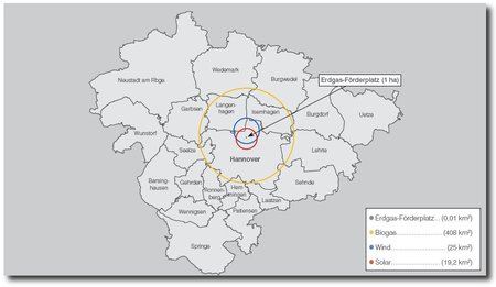
On a similar theme, Mark sends this map showing the area of land required to produce 300MW of power from various power sources, superimposed on a map of Hanover.
